Our lakes

  • All Lakes
  • Regions
    • Northland
    • Auckland
    • Waikato
    • Bay of Plenty
    • Hawke’s Bay
    • Taranaki
    • Manawatū/Whanganui
    • Wellington
    • Tasman
    • West Coast
    • Marlborough
    • Canterbury
    • Otago
    • Southland
  • Coastal Lakes
  • Lowland Lakes
  • Highland Lakes
  • Alpine Lakes
Menu
  • All Lakes
  • Regions
    • Northland
    • Auckland
    • Waikato
    • Bay of Plenty
    • Hawke’s Bay
    • Taranaki
    • Manawatū/Whanganui
    • Wellington
    • Tasman
    • West Coast
    • Marlborough
    • Canterbury
    • Otago
    • Southland
  • Coastal Lakes
  • Lowland Lakes
  • Highland Lakes
  • Alpine Lakes

Diamond Lake

Depth: 25 metres

Area: 177 hectares

Altitude: 314 metres

Lake ID: 54132

Main vegetation type:
Alpine Grass and Native Forest

Glenorchy

Otago
44° 44' 19" S
168° 22' 35" E
Alpine

Iwi / representative groups:

  • Ngāi Tahu
    • Hokonui Rūnanga
    • Kāti Huirapa ki Puketeraki
    • Te Rūnanga o Awarua
    • Te Rūnanga o Ōraka Aparima
    • Te Rūnanga o Ōtākou
    • Waihōpai Rūnanga

Description

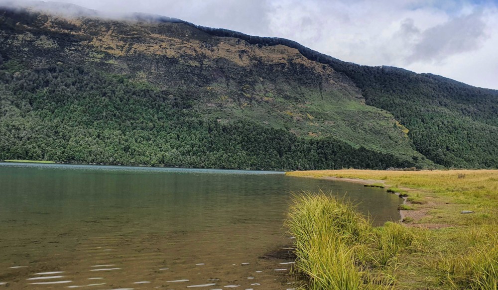
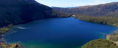
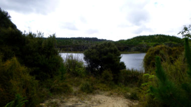
Diamond Lake is nestled under the eastern flanks of Mt Alfred, some 17 miles north of Glenorchy, on the edge of Mt Aspiring National Park. Diamond Lake Wildlife Management Reserve was established in 1981 to recognise the area’s superb wildlife and fisheries values. The lake is a popular camping and fishing spot. The western shore of Diamond Lake is steep and bush-clad. The lake drains south along Diamond Creek to the Rees River, via the smaller Reid Lake.

54132

Loading...

Blue Lake

Garvie Mountains

Southland

Lake Okowhao

Huntly

Waikato

Lake Pounui

South Wairarapa

Wellington

L51931

Te Anau

Southland

Lake Rototawai

Wairarapa

Wellington

Duncan Stream Tarn 2

West of Lake Pukaki

Canterbury

Explore our lakes

See all lakes
Lakes 380 reversed logo
About
Menu
  • The Project
  • The Science
    • Field Sampling
    • Laboratory Analysis
    • Student Projects
  • Science Aims
  • Rohe Studies
    • Rangitīkei Iwi Rohe Study
    • Wairarapa Moana iwi rohe study
  • Social Science
  • Iwi Relationships
  • The Team
    • Advisory Groups
    • Lakes380 Co-lead Institutes​
    • National Collaborators
    • International Collaborators
  • Partners
Our Lakes
Menu
  • All Lakes
  • Regions
    • Northland
    • Auckland
    • Waikato
    • Bay of Plenty
    • Hawke’s Bay
    • Taranaki
    • Manawatū/Whanganui
    • Wellington
    • Tasman
    • West Coast
    • Marlborough
    • Canterbury
    • Otago
    • Southland
  • Coastal Lakes
  • Lowland Lakes
  • Highland Lakes
  • Alpine Lakes
Resources
Menu
  • Contact & Links
  • Blog, News & Publications
  • Video Gallery
  • Results
  • Glossary
Contact Us

Email us

Twitter
Instagram
Envelope
Sign up to our newsletter for updates
Our Privacy Policy | Our Copyright Policy

© 2021 Lakes380 Project

Home

Our Lakes

Menu
  • All Lakes
  • Regions
    • Northland
    • Auckland
    • Waikato
    • Bay of Plenty
    • Hawke’s Bay
    • Taranaki
    • Manawatū/Whanganui
    • Wellington
    • Tasman
    • West Coast
    • Marlborough
    • Canterbury
    • Otago
    • Southland
  • Coastal Lakes
  • Lowland Lakes
  • Highland Lakes
  • Alpine Lakes

About

Menu
  • The Project
  • The Science
    • Field Sampling
    • Laboratory Analysis
    • Student Projects
  • Science Aims
  • Rohe Studies
    • Rangitīkei Iwi Rohe Study
    • Wairarapa Moana iwi rohe study
  • Social Science
  • Iwi Relationships
  • The Team
    • Advisory Groups
    • Lakes380 Co-lead Institutes​
    • National Collaborators
    • International Collaborators
  • Partners

Resources

Menu
  • Contact & Links
  • Blog, News & Publications
  • Video Gallery
  • Results
  • Glossary