Skip to content

Our lakes

  • All Lakes
  • Regions
    • Northland
    • Auckland
    • Waikato
    • Bay of Plenty
    • Hawke’s Bay
    • Taranaki
    • Manawatū/Whanganui
    • Wellington
    • Tasman
    • West Coast
    • Marlborough
    • Canterbury
    • Otago
    • Southland
  • Coastal Lakes
  • Lowland Lakes
  • Highland Lakes
  • Alpine Lakes

Lake Pukaki

Depth: 70 metres

Area: 17274 hectares

Altitude: 478 metres

Lake ID: 46564

South of Aoraki / Mt Cook Village

Canterbury
44° 4' 24" S
170° 10' 11" E
Highland

Iwi / representative groups:

  • Ngāi Tahu
    • Te Rūnanga o Arowhenua
    • Te Rūnanga o Moeraki

Description

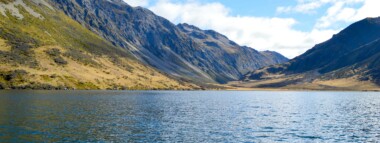
Lake Pukaki is a large glacial fed lake located between Tekapo and Twizel. Aoraki / Mount Cook towers above the northern end of the lake and on a clear day can be seen 70 kilometres away from the southern shore of the lake.
Lake Pukaki formed when the terminal moraines of receding glaciers blocked the valley, forming a moraine-dammed lake. The lake has very good water quality, with it’s distinctive blue colour coming from extremely finely ground rock particles from the glacier, known as glacial flour (https://en.wikipedia.org/). The lake is a reservoir for hydro electric generation (www.lawa.org.nz).
Lake Pūkaki was a kāinga nohoanga (food-gathering settlement) for Ngāi Tahu. Records show weka, pūtakitaki (paradise duck), aruhe (bracken fernroot), and tuna (eels) were gathered here (https://www.kahurumanu.co.nz/atlas).

46564
Loading...

Lake Carrot

Kaitaia

Northland

Lake Tahaaroa (Waikato)

Tahaaroa

Waikato

Lake Gow

Garvie Mountains

Southland

Lake Ida

Arthurs Pass

Canterbury

Katavich

Kaitaia

Northland

Long White Lagoon

Invercargill

Southland

Explore our lakes

See all lakes
Lakes 380 reversed logo
About
  • The Project
  • The Science
    • Field Sampling
    • Laboratory Analysis
    • Student Projects
  • Science Aims
  • Rohe Studies
    • Rangitīkei Iwi Rohe Study
    • Wairarapa Moana iwi rohe study
  • Virtual Experience
  • Social Science
  • Iwi Relationships
  • The Team
    • Lakes380 Team
    • Advisory Groups
    • Lakes380 Co-lead Institutes​
    • National Collaborators
    • International Collaborators
  • Partners
Our Lakes
  • All Lakes
  • Regions
    • Northland
    • Auckland
    • Waikato
    • Bay of Plenty
    • Hawke’s Bay
    • Taranaki
    • Manawatū/Whanganui
    • Wellington
    • Tasman
    • West Coast
    • Marlborough
    • Canterbury
    • Otago
    • Southland
  • Coastal Lakes
  • Lowland Lakes
  • Highland Lakes
  • Alpine Lakes
Resources
  • Contact & Links
  • Blog, News & Publications
  • Video Gallery
  • Results
  • Glossary
Contact Us

Email us

Twitter Instagram Envelope
Sign up to our newsletter for updates
Our Privacy Policy | Our Copyright Policy

© 2023 Lakes380 Project

Home

Our Lakes

  • All Lakes
  • Regions
    • Northland
    • Auckland
    • Waikato
    • Bay of Plenty
    • Hawke’s Bay
    • Taranaki
    • Manawatū/Whanganui
    • Wellington
    • Tasman
    • West Coast
    • Marlborough
    • Canterbury
    • Otago
    • Southland
  • Coastal Lakes
  • Lowland Lakes
  • Highland Lakes
  • Alpine Lakes

About

  • The Project
  • The Science
    • Field Sampling
    • Laboratory Analysis
    • Student Projects
  • Science Aims
  • Rohe Studies
    • Rangitīkei Iwi Rohe Study
    • Wairarapa Moana iwi rohe study
  • Virtual Experience
  • Social Science
  • Iwi Relationships
  • The Team
    • Lakes380 Team
    • Advisory Groups
    • Lakes380 Co-lead Institutes​
    • National Collaborators
    • International Collaborators
  • Partners

Resources

  • Contact & Links
  • Blog, News & Publications
  • Video Gallery
  • Results
  • Glossary