Skip to content

Our lakes

  • All Lakes
  • Regions
    • Northland
    • Auckland
    • Waikato
    • Bay of Plenty
    • Hawke’s Bay
    • Taranaki
    • Manawatū/Whanganui
    • Wellington
    • Tasman
    • West Coast
    • Marlborough
    • Canterbury
    • Otago
    • Southland
  • Coastal Lakes
  • Lowland Lakes
  • Highland Lakes
  • Alpine Lakes

Lake Rotoehu

Depth: 13 metres

Area: 790.1 hectares

Altitude: 297 metres

Lake ID: 40188

Main vegetation type:
Indigenous Forest/High Productivity Grassland

Rotorua

Bay of Plenty
38° 0' 54" S
176° 31' 54" E
Lowland

Iwi / representative groups:

  • Te Arawa Lakes Trust

    Description

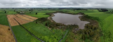
    Lake Rotoehu lies east of the Rotorua township and was formed by “lava damming” of a river valley. The catchment has a relatively even distribution in terms of land cover. Rotoehu has a maximum depth of 13.5 m, has geothermal inputs (possibly from groundwater sources) and has no true outlet (source www.lawa.co.nz).

    40188

    Download information sheet

    Sediment core

    Loading...

    Lake Killarney

    Takaka

    Tasman

    Lake Story

    Fiordland National Park

    Southland

    Lake Rotomānuka North

    Ohaupo

    Waikato

    Lake Karaka

    Pouto Peninsula

    Northland

    Lake Norma

    Fiordland National Park

    Southland

    Lake Eyles

    Fiordland National Park

    Southland

    Explore our lakes

    See all lakes
    Lakes 380 reversed logo
    About
    • The Project
    • The Science
      • Field Sampling
      • Laboratory Analysis
      • Student Projects
    • Science Aims
    • Rohe Studies
      • Rangitīkei Iwi Rohe Study
      • Wairarapa Moana iwi rohe study
    • Virtual Experience
    • Social Science
    • Iwi Relationships
    • The Team
      • Lakes380 Team
      • Advisory Groups
      • Lakes380 Co-lead Institutes​
      • National Collaborators
      • International Collaborators
    • Partners
    Our Lakes
    • All Lakes
    • Regions
      • Northland
      • Auckland
      • Waikato
      • Bay of Plenty
      • Hawke’s Bay
      • Taranaki
      • Manawatū/Whanganui
      • Wellington
      • Tasman
      • West Coast
      • Marlborough
      • Canterbury
      • Otago
      • Southland
    • Coastal Lakes
    • Lowland Lakes
    • Highland Lakes
    • Alpine Lakes
    Resources
    • Contact & Links
    • Blog, News & Publications
    • Video Gallery
    • Results
    • Glossary
    Contact Us

    Email us

    Twitter Instagram Envelope
    Sign up to our newsletter for updates
    Our Privacy Policy | Our Copyright Policy

    © 2023 Lakes380 Project

    Home

    Our Lakes

    • All Lakes
    • Regions
      • Northland
      • Auckland
      • Waikato
      • Bay of Plenty
      • Hawke’s Bay
      • Taranaki
      • Manawatū/Whanganui
      • Wellington
      • Tasman
      • West Coast
      • Marlborough
      • Canterbury
      • Otago
      • Southland
    • Coastal Lakes
    • Lowland Lakes
    • Highland Lakes
    • Alpine Lakes

    About

    • The Project
    • The Science
      • Field Sampling
      • Laboratory Analysis
      • Student Projects
    • Science Aims
    • Rohe Studies
      • Rangitīkei Iwi Rohe Study
      • Wairarapa Moana iwi rohe study
    • Virtual Experience
    • Social Science
    • Iwi Relationships
    • The Team
      • Lakes380 Team
      • Advisory Groups
      • Lakes380 Co-lead Institutes​
      • National Collaborators
      • International Collaborators
    • Partners

    Resources

    • Contact & Links
    • Blog, News & Publications
    • Video Gallery
    • Results
    • Glossary